Views And Coat Of Arms
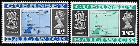
On October 1, 1969, Guernsey issued definitive stamps featuring „Views and coats of arms“. Two of the stamps displayed maps of Guernsey including longitude and latitude. The latitude read 40°30'N but should have read 49°30'N. In correction of that mistake did Guernsey issue two replacement stamps on February 2, 1970.
Top: Stamps with wrong latitude
Middle: Zoom into the blue stamps
Bottom: Corrected stamps
First Day Cover with corrected stamps
Withdrawn, controversial and exceptional stamps and other withdrawn postally issued items
| * | = | Withdrawn |
|---|---|---|
| ** | = | Controversial |
| *** | = | Exceptional |
| **** | = | Unclear |
Jimdo
Diese Webseite wurde mit Jimdo erstellt! Jetzt kostenlos registrieren auf https://de.jimdo.com


